|


|
|
Author
Index
S |
L
Neil Smith |
|
Title
Index
The |
The
Crystal Empire |
|
|
|
|
| Year |
1986 |
| Publisher |
Grafton
Books |
| ISBN |
0586200436 |
|
|
|
Synopsis
|
The
Kingdom of the
living Sun-God.
When the Black
Death wiped out
Europe in the
Middle Ages, other
civilizations rose
to take its
place. In
Rome the Saracen
Caliph ruled an
enlightened empire
in alliance with
the Jews. To
the east, the Arab
Mughal empire was
bent on its
destruction.
The Crystal
Empire was the
most powerful and
mysterious
civilization of
all - a Sino-Aztec
kingdom on the far
western shore of
the American
continent, ruled
by the living
Sun-God. But
what was the
source of their
power?
Sedrich
Sedrichsohn, a
heretic against
the oppressive
doctrines of the
Brotherhood of
Christ in Hell, an
outcast amongst
his own people,
was determined to
find out ... |
|
|
|
Review
|
There
are some memorable
scenes in this
book. I am
thinking
specifically of Comanche's
on motorcycles
attacking a
sail-driven
landship. Sound
ridiculous? Yet
Smith pulls it off
in this
alternate-history
novel in which
Europe is
decimated by the
plague, leaving
the world to other
cultures. It's a
big book, but it's
worth it. I liked
it, and you
probably will,
too.
Bob Wallace |
|
|
_______________________________________________________
 |
|
|
Credit:
NASA
|
|
Home
Reef
Reborn
In the
South
Pacific,
south of
Late
Island
along the
Tofua
volcanic
arc in
Tonga, the
volcanic
island
Home Reef
is being
re-born.
The island
is thought
to have
emerged
after a
volcanic
eruption
in
mid-August
that also
spewed
large
amounts of
floating
pumice
into
Tongan
waters and
swept
across to
Fiji about
350 km
(220
miles) to
the west
of where
the new
island
formed. In
2004, a
similar
eruption
created an
ephemeral
island
about 0.5
by 1.5 km
(0.3 by
0.9 miles)
in size;
it was no
longer
visible in
an ASTER
image
acquired
November
2005. This
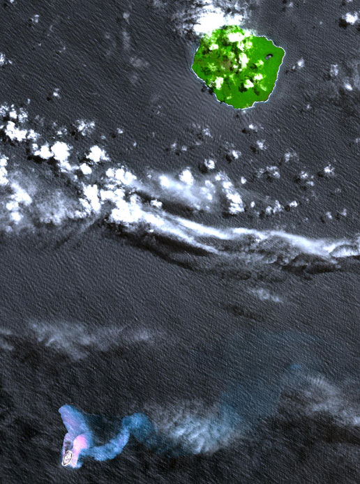
simulated
natural
color
image
shows the
vegetation-covered
stratovolcanic
island of
Late
Island in
the upper
right.
Home Reef
is found
in the
lower
left. The
two bluish
plumes are
hot
seawater
that is
laden with
volcanic
ash and
chemicals;
the larger
one can be
traced for
more than
14 km (8.4
miles) to
the east.
The image
was
acquired
Oct. 10,
2006 and
covers an
area of
24.3 by
30.2 km.
It is
located at
18.9
degrees
south
latitude,
174.7
degrees
west
longitude.
With its
14
spectral
bands from
the
visible to
the
thermal
infrared
wavelength
region,
and its
high
spatial
resolution
of 15 to
90 meters
(about 50
to 300
feet),
ASTER
images
Earth to
map and
monitors
the
changing
surface of
our
planet. It
is one of
five
Earth-observing
instruments
launched
Dec. 18,
1999, on
NASA's
Terra
satellite.
The
instrument
was built
by Japan's
Ministry
of
Economy,
Trade and
Industry.
A joint
U.S./Japan
science
team is
responsible
for
validation
and
calibration
of the
instrument
and the
data
products. |
|
NASA
Image of
the day
archive |
|
______________________________________________________
|
|


|

